|
|
Post by VeeVee on Jun 27, 2006 10:00:35 GMT -5
|
|
|
|
Post by bobcouttie on Nov 25, 2006 2:48:14 GMT -5
I recently wrote about Ramsey and the Charge at Morong by 26th Cavalry Philippine Scouts. Worth noting that this was the last charge by a United States Cavalry Unit (The Scouts wer US Army, not Commonwealth). |
|
|
|
Post by VeeVee on Nov 25, 2006 9:18:43 GMT -5
|
|
|
|
Post by VeeVee on Dec 9, 2006 0:18:30 GMT -5
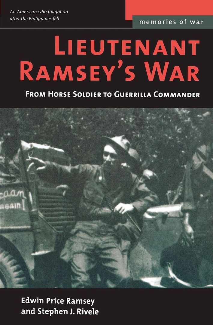
I read the account of the engagement and looked up satellite images of Morong, Bataan. I tried to picture and trace the flow of the skirmish based on the descriptions and came up with this.     The blue arrows are how I understand the direction of the Lt. Ramsey's attack went. ---------------- (Excerpt from Lt. Ramsey's War book)"There were three trails branching left off the road through Morong toward the sea. I signaled column left at the middle one, deployed the platoon in column of squads of eight men each, and gave the command to raise pistols. We watched as the point riders entered the town. There was silence as they made their way among the thatched huts. I ordered the troop forward. Morong looked deserted. The huts stood empty on their bamboo stilts, the pens beneath them long stripped of livestock by the retreating Allied army. The village center was the Catholic church, its only stone structure, and it too was closed up against the advancing Japanese. Beyond lay thick groves of coconut palms inclining through a swamp toward the sea, while to our right crossed by a single wooden bridge, was the narrow Batalan river, the line that Wainwright wanted to occupy. We moved carefully toward the village center, the horses maneuvering head-high among the woven huts, the men alert for movement. I watched the point guard turn in at the church square and disappear from sight, and then there was an explosion. Rifles and automatic weapons burst out from the center and northern end of the village, echoing among the huts and sendingjungle birds screaming.In a moment the point men came galloping back, one of the privates streaming blood across his horse's neck and flanks. An advance guard of the Japanese army had crossed the river and was passing near the church just as we had entered the village from the side. Now I could see scores of Japanese infantry in brown fatigues firing from the village center, and behind them hundreds more wading the river and crowding toward the Batalan bridge. In a few minutes more, the main body would be flooding across to seize Morong. Over the rattling of gunfire, I ordered my troopers to deploy as foragers, and raised my pistol. A charge would be our only hope to break up the body of Japanese troops and to survive against their superior numbers.For centuries the shock of a mounted charge had proved irresistible; now the circumstances and all my training made it instinctual. I brought my arm down and yelled to my men to charge. Bent nearly prone across the horses' necks, we flung ourselves at the Japanese advance, pistols firing full into their startled faces. A few returned our fire, butmost fled in confusion, some wading back into the river, others running madly for the swamps... The charge broke clear through the advance unit and carried on to the swamp, where we dismounted and grabbed our rifles from the scabbards. I threw out a skirmish line of one squad along the river to keep the main column from crossing and led the rest back into Morong to search for snipers." |
|
|
|
Post by legionnaire on Dec 11, 2006 23:14:47 GMT -5
Philip;
I'm still alive and kicking. As for your question,The trails and the Charge ran generally West toward the Ocean, to what was then a swamp which has now been cleaned out and shown as a small tributary running into or from the river. Nothing looks the same now as it was then. The last time I saw Morong was in 1990 and nothing looked the same, even then.
Regards,
Edwin P. Ramsey
Sent him the link to the satellite photos of morong.
|
|
|
|
Post by VeeVee on Dec 12, 2006 11:50:15 GMT -5
Thanks Philip. Things may have changed a lot since I can't reconcile the "narrow" Batalan river with the satellite image. The river looks wide, deep, and imposing to me. Draining and cleaning up the swamp area may have backed up the river and made it wider.
I'm sure none of the houses are "bahay kubos" anymore. The only thing that may have stayed the same is the location of the church, but who knows.
But I guess I got the arrows' general directions correct. Westwards... then they doubled-back after reaching the swamp area to clear the town.
|
|
|
|
Post by VeeVee on May 11, 2014 20:00:49 GMT -5
Trooper Dan Figuracion, the last surviving member of the charge confirmed to me at the last PSHS reunion that the direction of their charge was toward the sea, not toward the river. And that the church was on their right as they charged down the street.
|
|