|
|
Post by VeeVee on Dec 18, 2008 7:47:44 GMT -5
|
|
|
|
Post by 79thfoot on Dec 18, 2008 12:41:20 GMT -5
You know, Academy Minicraft used to do the B-17C's and D's - I really wanted to do a Clark Field Diorama at one point!
Lovely pic!
Tom
|
|
|
|
Post by rickthelibrarian on Dec 18, 2008 13:09:59 GMT -5
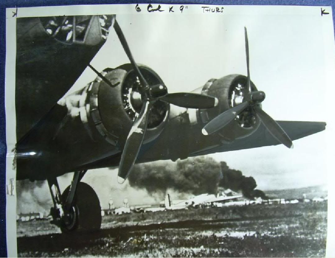
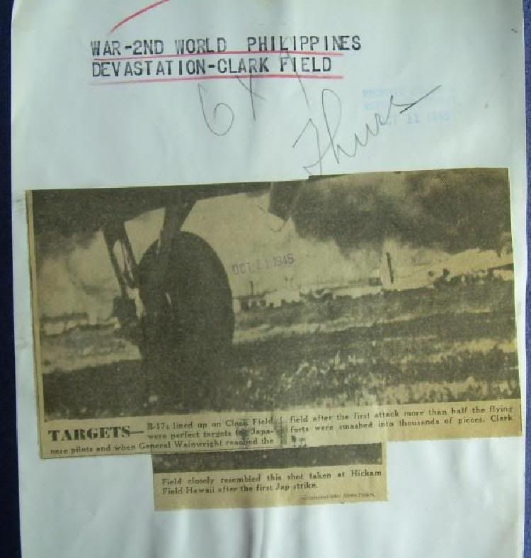
The picture is labeled incorrectly. The photo was taken at Hickam Field, near Pearl Harbor, shortly after the Japanese attack. The B-17 in the foreground is one of the 12 B-17s (this an E-model) that flew in from California during the attack. The B-17 in the background is a D-model, which was stationed at Hickam Field, where this photo was taken.
|
|
|
|
Post by eljefe on Dec 18, 2008 16:35:03 GMT -5
Yup, I agree with Rick. This is not Clark Field but Hickam Field in Hawaii. Here is a photo of the actual bombing of Clark Airfield on Dec. 8, 1941 at approx 20,000 feet  The two bombing runs done via North-West to South East by the G3M Nells of the 1st Kokutai which hit the runway areas and the G4M Bettys of the Takao Kokutai that hit the hangar areas. Rgds, |
|
|
|
Post by clarkfield on Dec 19, 2008 6:51:44 GMT -5
Now theres a good photo. Could I use it in my documentary? If so where could I get it? THANKS Chuck
|
|
|
|
Post by oklahoma on Dec 19, 2008 10:54:24 GMT -5
that japanese shot of the bombing run is the only aerial photo i have ever seen of the raid on clark field. i also have only seen a couple of photos of the damage on the ground taken by american photographers. they were of a couple of burned out B-17s on the flight line. i have always wondered why the shortage of an american photographic record of the raid's aftermath. maybe some were made and lost in the chaotic days following, but there just doesnt seem to any visual record floating around anywhere.
|
|
|
|
Post by legionnaire on Dec 19, 2008 16:47:54 GMT -5
their photographic equipment lab were probably all destroyed by the bombing, that's why no record was ever possible made.
Philip
|
|
|
|
Post by eljefe on Dec 19, 2008 18:37:27 GMT -5
Well actually, there are photos that DID make it but remained "classified". Even on the Japanese side which we have but am not allowed to post. This includes the Nichols, Iba and Batangas raids (as in before, actual and after recon photos)
|
|
|
|
Post by legionnaire on Dec 19, 2008 23:48:08 GMT -5
Still classified WWII photograhic aerial Documents? By the AFP? And to protect our most sophisticated advance top of the line stealth fighters that will stop any surprise Airborne attack on the Philippines. Does the AFP know about google earth? That means the PAF is still using the same original WWII airfield/ runway layout and facilities for its "WWII" aircraft" Now I really understand. I just shake my head in disbelief and sadness.  Philip |
|
|
|
Post by eljefe on Dec 21, 2008 9:07:47 GMT -5
Not by the AFP and PAF They dont' even have much in their photo collection on the early days of WWII. Those photos that I mentioned are from US sources, some are personal collections debriefing and captured newsreel and photos also from Japanese sources. Ex. what I have right now is a box of photos from a Japanese air recon unit on the attacks on Philippine airfields on Dec. 41, plus the Bataan and Corregidor attack sorties of 42. I gave my word not to disseminate it in public without the consent of theone who lent it to me for my research That is what I mean by "classified". However one thing I can say, these photos (90% of them unpublished) will answer a lot of unaswered questions and will also raise new ones.  As for the PAF if its still using the same runway layout during WWII. I would say both yes and no. Depends on what or where airfield you want to know. Philippine airfields is one area that I am focusing on right now FWIW, |
|
|
|
Post by oklahoma on Dec 21, 2008 15:03:28 GMT -5
having been involved to a degree with aerial photo interpretation at times while serving in USAF in korea in 1952-53 i was interested in the upper left hand portion of the japanese photo of the bombing. are these tents, quonset hut type billets, or stockpiled materials????if they are quonsets, clark was developed, in 1941, more extensively than i had imagined. "company" streets are layed out, etc so it would appear that it is a quonset or "tent city" type living area. on the other hand these "units" might be boxes/cartons/crates stacked in uniform rows. i think the latter possibility is unlikely. anyhow, just wondering what others might think. in comparing this photo with pre-war aerial shots of clark i cant locate fort stotsenberg or its parade field. they must be just off the photo to the upper left or top.
|
|
|
|
Post by eljefe on Dec 21, 2008 20:05:28 GMT -5
The "box' shaped things in the left hand of the photio are the Sawali hut made billets for the men stationed at Clark. You are right on your assessment on the Fort Stotsenberg parade ground which just starts on the upper most left part of the photo.
Clark has changed significantly from 1941. Even during Japanese occupation, they had built 6 runways inside the complex and when the Yanks came back in 45, they re-did the runway layouts as well.
|
|
|
|
Post by oklahoma on Dec 22, 2008 12:20:57 GMT -5
many thanks for clearing up my question about the objects that had me puzzled. i have, since elementary school, been overly (i guess) interested in the 1941-42 philippine campaign. my wife says its an obsession. maybe she's correct, although i have a two tract mind rather than a one tract mental setup since i do find time to fret about my beloved st louis cardinals. to illustrate my obsession about the early days of the war, back in 1953, when my tour of duty was winding down in korea, i volunteered for another overseas tour down at clark field. i would have gone to the PI in a heartbeat, but unfortunately no vacancy was open for my USAF job spec at the time. i was informed that there were two open slots on okinawa, but i tendered a big "no thanks" for kadena AFB. life just isnt fair as i had a very close friend from high school days who was stationed at subic bay navy station for 36 months. of course, this guy had no interest in the historical aspect of where he was stationed, spending the great majority of his free time in the bars,etc (if you get my drift) in olongapo and manila. i would certainly not been above such activities myself, but i surely would have found time to check out corregidor, clark, bataan, etc during a hitch at subic. as i said, life isnt fair. thanks again for the clarification on the clark photo. it does my 76 year old ego good to know that i havent completely lost my photo interpreter's touch. nice talking to you.
|
|
|
|
Post by legionnaire on Jan 17, 2009 18:53:34 GMT -5
The Actual bombing photo posted I found in a book idicates that Saburo Sakai took the photo.
|
|
|
|
Post by eljefe on Jan 26, 2009 3:43:08 GMT -5
I doubt if Saburo was able to take a photo of the actual bombing as himself together with the other fighter pilots of the Taina Ku took turns on doing straffing runs at Clark. Plus the angle of the photo does not coincide with the aircraft he was flying he was flying an A6M2b Zero which did not have a bottom window to make that flat shot possible. This may have been taken by an aircraft on the last "V" formation or by a C5M "Babs" who was also there to observe the bombing effects during and after the strike.
My two cents worth.
|
|